CONTACT
“The Crying Post Project: Post #4, The Children of Plutonium.” Sellafield, England.
Post Notes
"Say no more, you don't know who's listening." These were the first words I heard over the phone from the man who would become my contact for the post at Sellafield. Finding a local contact to help me with Sellafield was proving to be unusually difficult for some reason. I would later learn why.
British Nuclear Fuels Ltd. (BNFL) runs a nuclear processing complex called the Sellafield Station named after the nearby town. It has had a string of problems throughout its 52 years, notably a 1957 fire which released radioactive materials into the atmosphere, ultimately contaminating much of England and parts of Europe. During these years it has legally, illegally and accidentally discharged radioactive waste directly into the Irish sea, and contaminated the surrounding land, animals, and humans. The long and sordid history of governmental cover-ups and corporate lies fills pages and pages of text. Clearly, this site needed a Crying Post.
I finally found a woman named Jill who is a member of Friends of the Earth in Cumbria (the county which includes Sellafield), and lived in nearby Maryport. She was enthusiastic about helping me out. Unfortunately, she was going to be out of town while I was there, but she put me in touch with another woman who put me in touch with Dave Millwart. It was Dave who spoke those fearful words mentioned earlier.
When I finally found his place in Maryport, it was obvious that I had found an unrepentant ‘60s hippy. And, as he explained to me the local culture and politics, his caution and my difficulty in finding collaborators became clear. First of all, one of the most economically depressed areas of England is here. Sellafield is just about the only employer. So even for people who may not like what BNFL is doing, they have few alternatives. Some like Dave, a former band manager and music writer, earns some money showing school children how to build a yurt. The other impediment to finding help comes from the general local distrust of outsiders. This insularity is such - as Dave explained - that although a woman married a man from the next village over -years ago- the husband has still not been fully accepted.
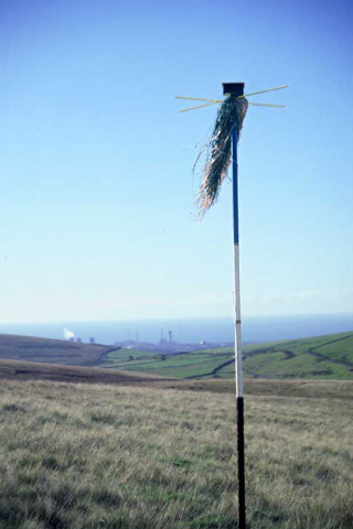
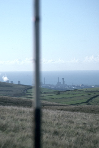
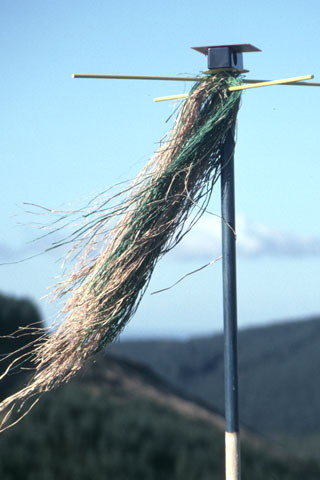
Clearly there would be no chance for an "officially approved" post. However, just west of the complex was a beautiful hilly area called the Lake District national park. It was felt that we should be able to find a sufficiently safe and remote location. So after the obligatory english tea, we were off. As you can see from the photos, we found the perfect spot, one with the Sellafield complex’s cooling towers as the backdrop.
"Say no more, you don't know who's listening." These were the first words I heard over the phone from the man who would become my contact for the post at Sellafield. Finding a local contact to help me with Sellafield was proving to be unusually difficult for some reason. I would later learn why.
British Nuclear Fuels Ltd. (BNFL) runs a nuclear processing complex called the Sellafield Station named after the nearby town. It has had a string of problems throughout its 52 years, notably a 1957 fire which released radioactive materials into the atmosphere, ultimately contaminating much of England and parts of Europe. During these years it has legally, illegally and accidentally discharged radioactive waste directly into the Irish sea, and contaminated the surrounding land, animals, and humans. The long and sordid history of governmental cover-ups and corporate lies fills pages and pages of text. Clearly, this site needed a Crying Post.
I finally found a woman named Jill who is a member of Friends of the Earth in Cumbria (the county which includes Sellafield), and lived in nearby Maryport. She was enthusiastic about helping me out. Unfortunately, she was going to be out of town while I was there, but she put me in touch with another woman who put me in touch with Dave Millwart. It was Dave who spoke those fearful words mentioned earlier.
When I finally found his place in Maryport, it was obvious that I had found an unrepentant ‘60s hippy. And, as he explained to me the local culture and politics, his caution and my difficulty in finding collaborators became clear. First of all, one of the most economically depressed areas of England is here. Sellafield is just about the only employer. So even for people who may not like what BNFL is doing, they have few alternatives. Some like Dave, a former band manager and music writer, earns some money showing school children how to build a yurt. The other impediment to finding help comes from the general local distrust of outsiders. This insularity is such - as Dave explained - that although a woman married a man from the next village over -years ago- the husband has still not been fully accepted.
Clearly there would be no chance for an "officially approved" post. However, just west of the complex was a beautiful hilly area called the Lake District national park. It was felt that we should be able to find a sufficiently safe and remote location. So after the obligatory english tea, we were off. As you can see from the photos, we found the perfect spot, one with the Sellafield complex’s cooling towers as the backdrop.
The 1957 Fire at Windscale
In the early morning of October 10, 1957, the operators at Windscale Pile no.1 started work to release the energy that had been accumulating in the graphite of the reactor (Wigner energy). The bombardment of neutrons within the reactor caused large amounts of energy to accumulate in the form of heat in the graphite, so this procedure needed to be regularly executed. Failure to release the energy would cause a build-up of heat within the graphite that could eventually start a fire.
The precise cause of the fire that broke out on that day is still unknown, but the most probable reason seems to be that the operators did not execute the operation with the same caution as earlier. Furthermore there were no satisfactory safety procedures governing how the operation should be executed. By the time the alarm went off, the reactor was completely ablaze. The operators tried to pull out fuel elements from the reactor in an effort to prevent the release of radiation, but the fire in the graphite was so advanced that there was no longer time to accomplish this. The failure to control the fire in the graphite resulted in an extensive fire inside the reactor core which lasted for more than 24 hours.
The fire resulted in two serious releases of radioactivity. The first discharge came as a consequence of the natural uranium inside the reactor core catching fire. The second serious discharge came early on Friday, October 11, when the reactor was showered with water in an attempt to extinguish the fire. A huge cloud of steam transported radioactive particles and gases out in the atmosphere. The radioactive cloud drifted southwards, over most of England, and continued over Europe. At about 11a.m. the same day, the fire was under control. More than 20% of the reactor core was damaged in the fire. On the plant site, workers had been exposed to radiation doses 150 times higher than the prescribed dose limit. Some members of the local population were exposed to radiation doses 10 times higher than the maximum lifetime doses. UKAEA was aware of the high radiation levels, but nevertheless, decided against evacuating the population.
The day after the fire, the authorities halted the distribution of milk from 17 farms in the district, and on October 12, the Medical Research Council ruled that milk containing more than 3,700 Bq per liter should not be used. It was assumed that this limit would affect the entire milk production within an area of approximately 500 km2; consequently, milk from this area was banned. The highest activity measured in one of the milk tests was as high as 50,000 Bq per liter. This milk originated from a farm 15 kilometers away from the reactor. Iodine absorption to the pancreas was also registered, with the highest measured dose registered at 160 mGy.
However, three days after the drastic measures went into effect, it was discovered that milk produced outside the most exposed area was also polluted with iodine-137. Tests on milk from a farm in Grasmere in the Lake District showed concentrations of between 4,400 Bq per liter and 6,600 Bq per liter. Yet despite these finds, the milk was distributed to the market, and the documents verifying these figures were classified as secret by the government, in order to avoid instilling "unnecessary fear" in the population.
The majority of the restrictions on the distribution of milk were lifted on November 4, in the same year, whereas the remaining restrictions were removed on November 23, only about a month after the accident. A total of two million liters of milk containing iodine-131 were dumped into the ocean or nearby rivers.
Some efforts were later made to estimate the amount of radioactive discharges. It is believed that the accident led to discharges of between 600 and 1,000 TBq of iodine-131, between 444 and 596 TBq of tellurium-132, between 22.2 and 45.5 TBq of caesium-137 and about 0.2 TBq of strontium-90. An estimate of 1369 TBq of Polonium-210 was also realized during the fire.
Prime Minister Macmillan put a lid on all information concerning the accident. The Prime Minister feared that the accident reports, in drawing attention to an earlier accident in 1952, as well as suggesting that the 1957 accident was a result of operational failure and unsatisfactory instruments, would impair the people’s confidence in the nuclear energy programme, and furthermore delay the development of British nuclear weapons. Macmillan publicly declared that complete openness about the accident could jeopardize the national safety.
A period of 25 years passed before official estimates on how the accident had affected the population’s health were made public. In 1982, the British National Radiological Protection Board issued a report which it described as the full truth about the Windscale accident. The report suggested that 32 deaths and at least 260 cases of cancer could be attributed to the radiation releases as a consequence of the fire. Independent experts however, claim that from a broader perspective, the fire actually claimed more than 1,000 lives.
After the accident, in an attempt to get rid of unfavorable associations, UKAEA changed the name of the plant from Windscale to Sellafield - a name with just as many bad associations to it.
Bellona Working Paper on Sellafield
http://www.bellona.no/en/energy/nuclear/sellafield/wp_5-2001/21871.html
Cumbria
The Cumbria High Fells is characterized by a combination of rugged mountains, radiating ridges, steep scarps and glaciated valleys contrasting with the green dales with lakes, rivers woods and forests. The wild, exposed and open high fells are characterized by rough grassland, dwarf shrub heaths, peatlands, bracken and areas of rock outcrop and screes. Deep, U-shaped glaciated valleys radiate from the central core of the area to form typically steep sided, open, rugged fellsides with rocky outcrops and boulder-strewn fields. The exposed hillsides, which consist of unimproved rough grazing land and are drained by narrow ghylls and streams, form semi-wild and rugged landscapes. Mosaics of semi-improved grasslands, woodland blocks and scrubby vegetation occur at lower altitudes in association with marginal and in-bye land surrounding farmsteads. These more gently sloping fells are enclosed by stone walls which form strong patterns in the landscape, are generally more sheltered and are softer in appearance.
Two broad groups of rocks influence the scenery of the Cumbrian Mountains. The oldest rocks in the Lake District, the Skiddaw Group, formerly known as the 'Skiddaw Slates', comprise a succession of mudstones, siltstones and greywackes of Ordovician age, all of which have been altered or metamorphosed. The central part of the Lake District, coincides with the outcrop of the Borrowdale Volcanic Group. This is a complex sequence of volcanic rocks of Ordovician age, composed of lavas and volcanic sediments. All have suffered some alteration or metamorphosis as a result of the intrusion of a large underlying body of granite. All of these Lake District rocks host a variety of mineral veins. These carry the ores of copper, lead, zinc and a variety of other metals.
The native upland forests were cleared in Neolithic times to provide grazing land for sheep, pigs, goats and cattle. This activity led to impoverishment of the soils which has continued through the centuries. There is evidence that the Neolithic people were skilled geologists in recognizing that only fine-grained volcanic rocks would produce sharp axes. As a result axe factories were established on the Langdale Pikes and the Scafells. Neolithic stone circles are found in the high fells and valleys, together with other cairns, earthworks and ancient roads and tracks over high passes.
The land cover of the Cumbria High Fells reflects the landform and climate of the area and the influence of management since prehistoric times when broadleaved woodlands covered all but the highest crags. They have lost most of their natural woodland cover, suffer from impoverished soils, are subject to soil erosion and are undergoing major ecological change as a result of subsidy-induced overgrazing.
The high fells today consist predominantly of grasslands with a range of dwarf shrubs, heaths, peatlands and bracken, with broadleaved woodland on the deeper soils. Rocky outcrops and screes also are common. Dry moss heaths and lichen communities, Arctic alpine flora and mires and wetland vegetation are also found on the higher summits, cliffs and gills. Juniper scrub/woodland and oak woodlands are characteristic. Bracken is scattered on the fells and grows more densely on steeper fellsides, intakes and in woodland.
The lower fells and gently sloping valley sides support semi-improved and improved grasslands, and enclosed farmland located on the floor of the valleys is characterized by a mosaic of meadows and pastures, unimproved and herb-rich, together with woodlands and ornamental parkland. Wetlands and mires are found on plateaus and valley heads. Wetland habitats such as valley and basin mires and marsh and fen vegetation are also important elements in the lowland landscape. There is a lack of natural waterside vegetation on lake and river margins due to intensive grazing and access pressure. There is very little unimproved grassland in the valleys.
Broadleaved woodlands are found on the lower slopes of the valleys and in the sheltered gills but the density and vigor of the vegetation cover decreases with altitude so that only sparse scrubby woodland is found on the steeper valley sides.
The Countryside Agency
http://www.countryside.gov.uk/LivingLandscapes/countryside_character/north_west/cumbria_high_fells.asp
Post Place
N 54° 29.666'
W 003° 26.943'
Elevation 297 m (976')
Cumbria is a creation of 1974, and comprises the former counties of Westmorland and Cumberland, the district known as Lancashire North of the Sands (Furness and Cartmell), and the 3 parishes around Sedbergh, formerly in Yorkshire – altogether over 1.6 million acres with nearly 500, 000 people in a district measuring roughly 75 miles by 75 miles. At its heart is the superb lake district; on the east the Pennine mountains; on the north Scotland, the Irish Sea to the west and Lancashire to the south. A broad band of fertile and lowlying agricultural land skirts the lakeland core, and there are any number of market towns, villages, the county capital of Carlisle, and larger industrial towns like Barrow, Kendal, Whitehaven and Workington.
There was considerable Christian presence in Cumbria under the Roman occupation, and Christianity continued after the leaving of the Romans. [However,] the Vikings or Norse arrived c800 AD and destroyed many monastic centers. The 9th and 10th century settlers from Ireland were actually Norse, and their way of life included a mixture of religious expression. Despite the Pagan, Christianity continued to live openly; in spite of Christian success, Paganism continued to flourish. The important crosses, to be found especially in West Cumbria, illustrate this confusing mixture of Christian and Pagan, and could be interpreted as belonging to either tradition.
Cumbria possesses more than its share of crosses, and is part of the Celtic fringe of Christianity which was flourishing in Ireland, Wales and the far west of Scotland long before the arrival of Rome’s missionaries in Kent in the 590s. [The] Gosforth cross is of c990 and stands 15 feet high. The cross base is assumed to grow into the full cross - but is it developing into the World Ash, Yggdrassill, whose roots reached down to the dead in hell and whose branches reached sky and heaven? Is it Christ, or is it Baldur, the Christlike figure of Norse religion? The sculptor or the person who commissioned the piece was taking no risks at either side, Pagan or Christian, losing the fight.
Over the last 6,000 years of human existence the landscape of Cumbria has undergone repeated and radical change. Thick forests of birch or oak or yews or scrubwillow at carious times, marsh and swamps, have been cleared by men and their animals (and above all by goats, the most destructive of all). What we see today we should not take for granted as always having been there: bare mountains once had trees, and not the wretched pines of nowadays.
A wealth of trees and plants encouraged Cumbrian Pagans to see them as special. Oak was the guardian of men against magic of the worst kind, guarantor of fertility for animals and men, used for boundary marking, and employed to make the best houses. An oak above the well or spring was ideal. Ash trees, the Norse magic tree, brought and supported all life, for man was born in legend of the ash, and women from the alder. Ash, mountain ash or rowen, was used as charms to protect children against ill health or witches; twigs of either were placed in barns to protect animals, and with due reverence and correct procedure diseases could be transferred to their trunks and barks.
Pagan Cumbria/ John Burgess
The Children of Plutonium
Adults who work in facilities that handle plutonium and other radioactive materials may unwittingly pass on cancer to their future children. This is the implication of a detailed scientific study recently carried out by British epidemiologist Martin Gardner and his colleagues, to examine anecdotal reports that cancer rates are excessively high for children who live near the Sellafield plutonium reprocessing plant in Great Britain.
Gardner and his colleagues concluded that the increased incidence of leukemia and non-Hodgkin's lymphoma among children in the vicinity of Sellafield is correlated with paternal employment at the plant. The results indicated that a father's exposure to routine low-level radiation on the job at Sellafield increases six- to eight-fold his children's risk of contracting leukemia or lymphoma. The Gardner findings are unprecedented, because they suggest that exposure to very low levels of radiation - well within accepted safety standards - may be sufficient to induce cancer in offspring.
Not surprisingly, the Gardner study has been highly controversial. The nuclear industry maintains that Gardner's contention is impossible because there are no known biological mechanisms for it, and because it is not observed in the data from survivors of the nuclear attacks on Hiroshima and Nagasaki. (Conventional wisdom on radiation safety relies heavily on the epidemiological data obtained from the aftermaths of attacks on Hiroshima and Nagasaki.) However, numerous radiation health experts believe that Gardner's results constitute a crucial new discovery of the potentially devastating effects of long-term exposure to low levels of radiation. They argue that there are several biological reasons why Gardner's results would not be observed among the survivors of Hiroshima and Nagasaki. For example, the bomb survivors received only a single dose at the time of explosion, whereas the Sellafield workers are subjected to continual low-level exposure over a long period of time. Also, the type of radiation in the two cases was different, and furthermore, most of the parental subjects in the bomb data were pre-pubescent children when exposed, whereas the Sellafield workers were sexually mature adults.
Dr. Scott Davis of the Fred Hutchinson Cancer Research Center in Seattle, Washington, provided crucial testimony [during a court hearing]. Davis is director of the large-scale Hanford Thyroid Disease Study authorized by the U. S. Congress and funded through the federal Centers for Disease Control. Davis is widely regarded as one of the most objective unbiased epidemiologists studying the effects of ionizing radiation. His reputation stems from the fact that the statistical conclusions from his previous research projects have in some cases lent support to environmentalists' concerns about radiation safety, and in other cases supported the nuclear industry's sanguine position.
Davis performed an exhaustive review of the voluminous literature relevant to Gardner's findings to determine whether Gardner's results were supported or refuted by relevant studies conducted elsewhere.
Based on his review of 65 studies of the incidence of cancer near nuclear facilities in various countries, he concluded that the weight of the evidence is consistent with an increase in leukemia risk associated with proximity to or probability of exposure from nuclear facilities. He testified that the excess cancers around Sellafield are thus not an isolated occurrence, and are therefore unlikely to be due to chance. Davis concluded that on balance, it is likely that the Sellafield workers' exposure to radiation contributed to the excess leukemias and non-Hodgkin's lymphomas in their children.
Martin Gardner and his colleagues have advanced the hypothesis, based on epidemiological evidence, that the risk of cancer developing in children of parents who work at the Sellafield plutonium reprocessing plant is six to eight times higher than normal. This hypothesis has been subjected to an unusually high degree of critical review in the form of numerous studies undertaken to explore this phenomenon further, as well as the exhaustive review carried out by Davis. The results of this review suggest that Gardner's hypothesis holds up under the most rigorous scrutiny and must therefore be taken seriously.
Not only might far more stringent radiation standards need to be enacted, but our entire understanding of the harmful biological effects of ionizing radiation may have to be radically revised.
The implications of Gardner's hypothesis are potentially quite profound. If it is true that workers' exposure to routine low levels of radiation can significantly increase the risk of cancer in their offspring, this will likely open up an altogether new domain of concern about radiation health safety, because the minuscule doses involved were previously deemed quite safe. Not only might far more stringent radiation standards need to be enacted, but our entire understanding of the harmful biological effects of ionizing radiation may have to be radically revised and expanded to account for these new low-dose effects. Moreover, meeting extremely strict radiation standards in industrial operations may be very difficult to achieve in practice. These developments would likely constitute yet another significant blow to the nuclear power industry, and would probably drive up the cost of nuclear power considerably at a time when the nuclear industry is already weak from a lack of economic competitiveness. Hence, the Gardner findings could serve to accelerate the decline of the nuclear power era.
Meanwhile, what of the thousands of workers in nuclear plants who now must wonder if their children will soon develop cancer? Or whether they should dare to have children at all? Or those whose children already have cancer?
William Keepin, Ph.D/Nuclear Guardianship Forum, #3, Spring 1994
http://www.coopcomm.org/nonukes/w15cancr.htm
A Network of Information
Megalithic structures [such as Avebury, Carnac, Callanish and Stonehenge] indicated the positions of the solstices and equinoxes, which could be used for checking the accuracy of the calendar. They also embodied the information required for the determination of irregular events, such as long-term cycles of the sun and moon, their perturbations and eclipses. To this end, complex astronomically oriented structures were constructed all over the planet, combining a religious with an observational and record-keeping function. Of such observatories, which were constructed by many ancient civilizations, Stonehenge on Salisbury Plain in England is the most celebrated and probably the most studied.
For centuries it has been known that sunrise on midsummer day can be viewed from the center of the circle over the Heelstone along the approach avenue. Many surveys, more or less accurate, have been made of Stonehenge, and it was only a matter of time until each and every part of this remarkable edifice was accounted for. In 1963 Gerald Hawkins, professor of astronomy at Boston University, published a paper in Nature which suggested that the twelve major alignments of sunrise and moonrise, eight lunar and four solar, were delineated by the relative positions of the Stonehenge stones. The next year he announced his discovery that the 56 "Aubrey holes," the excavated remains of one of the earlier circles on the site, could have been used in the prediction of lunar eclipses.
Among other fascinating facts concerning the geometry of the stones’ positions, Hawkins showed that Stonehenge could not function elsewhere without alteration being made to its geometry. For instance, the only place where the four "station stones" which determine lunar and solar alignments would form an exact rectangle is at the latitude of Stonehenge. Move it but a few miles to the north or south, and the geometry would no longer be functional.
The Ancient Science of Geomancy /Nigel Pennick
Slow Motion Chernobyl
The Sellafield nuclear complex is situated on the coast of Cumbria in north-west Britain. Originally named Windscale with the purpose of producing plutonium for the British nuclear weapons program, it is now a commercial operation with reprocessing facilities, fuel fabrication and other installations.
Sellafield has a very bad safety record with hundreds of accidents involving the release of radioactive substances into the environment and the irradiation of workers and equipment. As a result, about 60 percent of the buildings have to be classed as nuclear waste.
The Sellafield site has the highest concentration of radioactivity on the planet. An accident involving the liquid high level waste tanks would have catastrophic consequences and make the area uninhabitable for a long time.
The reprocessing plants discharge some eight million liters of nuclear waste into the sea each day. The radioactivity contaminates seawater, sediments and marine life such as winkles and lobsters. The Irish sea is the most radioactively contaminated sea in the world.
In the vicinity of the complex, groundwater, estuaries and soil are contaminated. Compared to the British average, there has been a ten-fold increase of childhood leukemia around Sellafield. Plutonium dust has been found in the houses of residents living along the Irish Sea coast.
British Nuclear Fuels Ltd (BNFL), the Sellafield operators, are notorious for mismanagement, cover-ups and lies. They have exceeded discharge limits, ignored safety regulations and falsified data on numerous occasions.
-
[Data] released by Greenpeace reveal for the first time the levels of pollution in sediments at the end of Sellafield's nuclear waste discharge pipe. A sample of the sediment, collected by divers in full-protection suits, shows the sea-bed itself has been so contaminated as to classify it as nuclear waste under European Commission (EC) standards.
The sediment collected by Greenpeace and analyzed for gamma radiation at the University of Wales, Bangor, contains a mixture of dangerous radioactive isotopes including Americium, Cesium and Cobalt. Americium is one of the most radiotoxic substances in the world, as deadly as plutonium. Cobalt 60 has the potential to contaminate any life-form which gets in contact with it and can provoke various forms of cancers and blood-poisoning.
According to EC regulations, the high levels of Americium and Cesium found in the sample require that it be treated as controlled nuclear waste. In addition, according to the UK government's own standards, the sediment should be classified as nuclear waste and stored at a special repository. The highly radioactive sample was taken from the sea floor as a team of three divers made their first dive on one of the Sellafield discharge pipes on May 23. Wearing fully-sealed high-protection suits and lead boots, the divers took the sediment sample near the end of the discharge pipe, at a depth of some 20 meters and a distance of 2 kilometers from land.
According to Damon Moglen of Greenpeace International "[The nuclear waste] is just lying on the ocean floor, a shocking example of marine pollution. BNFL has turned the sea-bed into a nuclear waste dump. Discharges of nuclear waste from Sellafield's pipe must stop."
Radioactive contamination from Sellafield has spread through the marine environment off the English, Scottish and Welsh coasts. Traces of this dangerous nuclear waste are retained in crabs, clams, fish and seaweed. The contamination also spreads westward to the coast of Ireland (some 90 miles away) and northward along the North Sea coasts of the Netherlands, Germany and up into Nordic and Arctic waters.
-
Even though the discharges from Sellafield were dramatically reduced in the early 1980s, the plant remained the worst nuclear polluter in Europe,[103] despite BNFL having dealt with the most serious corrosion problems related to spent fuel. In 1984, Sellafield was responsible for 90 percent of the British people’s annual radiation dose in the form of discharge from nuclear plants. In 1987 this number fell to 60 percent.
On November 18, 1983, a mistake by workers at BNFL’s Magnox reprocessing plant resulted in an uncontrolled discharge of radioactivity into the ocean. The discharge spread along the coast and polluted the beaches in the area. It was found that the level of radioactivity in for example seaweed along the coast was so high that the Ministry of the Environment closed off more than 20 kilometers of the beach area. A major effort to clean up the beaches was commenced, and restrictions on using the beaches remained in effect until the following summer. The authorities claimed they had not been informed of the accident until a week after it had happened. After a police investigation of the case, BNFL was fined Ł10,000, paying in addition legal costs amounting to Ł60,000.
In the early 1980s, British researchers discovered that the plutonium content in shellfish from off the coast of Sellafield was five times higher than normal, and as a consequence, the radiation contribution from plutonium to the so-called "critical group" was adjusted to a factor of 15.
Because mankind is positioned high up on the food chain, we are more exposed to radioactive radiation. In 1984 the governmental Waste Management Advisory Committee ascertained the population living in certain areas close to Sellafield, through their food intake alone would receive 69 percent of the critical dose limits as set by the International Commission on Radiological Protection (ICRP). Furthermore, researchers connected to the Department of Environmental Studies ascertained that the population in the area was exposed to radiation through fission products, either washed ashore by the tide in the form of tiny particles mixed together with fine sand and other sediments, or borne through the air in the form of sea mist which the population then might inhale.
It was established therefore that the entire coastline from Maryport in the north to Wyre in the south was severely polluted by americum-241. The same researchers ascertained that plutonium had a greater ability to bind to organic material on the bottom of the sea than was previously believed. Hence plutonium could reach humans more easily through the food chain than it would have had if it remained on the sea bottom bound to non-organic material.
-
The area around the Sellafield reprocessing plant (UK) is as heavily contaminated with radioactivity as the zone around the stricken Chernobyl reactor in Ukraine. This is the conclusion emerging from the analyses of soil samples from both areas commissioned by Greenpeace to the University of Bremen.
Over the past few weeks the University of Bremen analyzed the samples taken by Greenpeace in the area around Chernobyl. A comparison with radioactive pollution in the area around the UK reprocessing plant at Sellafield leads to the alarming conclusion that some of the figures for radioactivity at Sellafield are even higher than those for the Chernobyl area.
"Sellafield is a slow-motion Chernobyl, an accident played out over the last four decades," said Mike Townsley of Greenpeace International. "While an area of 30km radius around Chernobyl is prohibited access for people and any agricultural activity, there are no such restrictions around Sellafield".
1. http://archive.greenpeace.org/
2. http://archive.greenpeace.org/
3. Bellona Working Paper on Sellafield, http://www.bellona.no/en/energy/nuclear/sellafield/wp_5-2001/21895.html
4. http://archive.greenpeace.org/
That Spirit Whose Body Is Earth
I THINK of earth as the floor of a cathedral where altar and Presence are everywhere. This reverence came to me as a boy listening to the voice of birds one coloured evening in summer, when suddenly birds and trees and grass and tinted air and myself seemed but one mood or companionship, and I felt a certitude that the same spirit was in all. A little breaking of the barriers and being would mingle with being. Whitman writes of the earth that it is rude and incomprehensible at first. "But I swear to you," he cries, "that there are divine things well hidden." Yet they are not so concealed that the lover may not discover them, and to the lover nature reveals herself like a shy maiden who is slowly drawn to one who adores her at a distance, and who is first acknowledged by a lifting of the veil, a long-remembered glance, a glimmering smile, and at last comes speech and the mingling of life with life. So the lover of Earth obtains his reward, and little by little the veil is lifted of an inexhaustible beauty and majesty.
The Candle of Vision: Inner Worlds of the Imagination/ George Russell
The Ash Tree
The Common Ash is native to northern Europe and the British Isles. The ash is graceful, with pale gray bark and feathery leaves. Ash woods are light and airy and the trees grow quickly, although they tend to sour the soil around them, so other plants do not thrive there.
The ash is central to the beliefs of many ancient world cultures and is thought to be the tree from which the essence of humankind originated. The ash was always of great magical importance to the ancient Irish. In Northern European legend, the ash is seen as the Great World Tree, a symbol of universality, which spreads its roots and branches over every land and forms a link between the gods, humankind, and the dead. Yggdrasill, the Enchanted Ash, marked the center of the universe, around which everything flowed. At its root was a serpent that represented female earth energies and in its crown was an eagle that was symbolic of the male energies of the sky.
The ash eventually replaced the birch as the maypole, becoming a symbol of the creative life-giving energy of the sun god, instead of being a celebration of the potential of the virgin goddess as it once was. The ash is also connected to the waters of life and is associated with the sea and the power of the sea.
A druid’s wand is made from ash, as it was said to protect from malign influences. The ash holds a key to Universal Truth, and for the Celts is was the guardian of those truths. It is the tree of balance and the Marriage of Opposites, and it links our inner and outer worlds.
In ancient Britain the ash was associated with rebirth and new life and was famous for its ability to heal children, who were passed through a split in the tree’s trunk in order to be cured.
-
In medieval Europe, the ash was a tree "that will tolerate nothing poisonous within its shadow," and was used to counteract all types of poisons.
1. The Wisdom of Trees/Jane Gifford
2. Sacred Trees/Nathaniel Altman