CONTACT
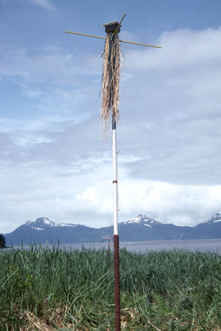
“The Crying Post Project: Post #8, Waiting for Justice.” Bligh Island, Alaska, USA.
Post Notes
You are all familiar with the Exxon-Valdez oil spill of 16 years ago. You've seen the pictures of oil-soaked wildlife, the black waters, the dead. Although the "official" Exxon supplied amount of oil spilled is 11 million gallons, independent research has determined that the number is at least 30 million gallons. The recovery of the Prince William Sound's unique ecosystem - and that of the health of human beings - remains open to debate. What is not open to debate is the willful shortsightedness that allowed this to happen, and the government and corporate corruption subsequent to the spill. What is not open to debate is the almost complete destruction of the careers and lives of the Sound's fishermen, and their treatment by a downright cruel, even sadistic Exxon Corp. And finally, what is not open to debate, is that this is all business as usual.
My guide into this murky world was Bob Sanford. He has fished in the Sound for decades, and was not far from the "accident" site when it occurred (is it really an accident when it was eventually bound to happen). He participated in the cleanup, and like all of the other fishermen he initially trusted Exxon to make good, only to be left hanging, still, 16 years later. Bob is hanging on, just. His past, present and future income; money for his children's education, and his retirement, has however, been radically diminished, in ways many of us cannot even imagine. [As announced today (June 26, 2008) the U.S. Supreme Court in an unprecedented ruling cut the original punitive damages by 90%. It will leave peanuts for the suffering fishermen.]
Bob who fortunately still has his boat - although he now spends more time running tourists out for far less than he should be making fishing - took me out to Bligh Island, next to Bligh Reef where the ship ran aground. In this case I received permission for the installation from the Tatitlek Corporation. This "corporation" was actually created as a way for the U.S. government to address the land claims of the First Nations people who originally lived there. This in itself is a fascinating and complex story with the expected mixed results, which unfortunately, I won't be able go into here.
So on the boat trip we had 3 hours out and 3 hours back for me to hear many of the less publicized details of the whole corrupt fiasco. As I mentioned Bob was in the water when the ship went aground. The response from the ship to radioed offers of help was "We don't need no help from any fucking fishermen." This was an attitude carried througout the entire cleanup toward any unsolicited suggestions from men who spent their lives in this water, and had an intimate and deep understanding that may have been beneficial. An example of Exxon's shortsightedness and stinginess is this. Herring fishermen have these huge pumps they use to "vacuum" up the fish from the water. They could have been easily and efficiently used to vacuum up the oil. Exxon refused the offer as they didn't want to pay for the subsequently necessary pump replacements. In an amusing if it weren't so painful story of ignorance, Exxon officials tried to disperse "oil slicks" that were quite obviously herring.
Bob described the oil spill as "black oatmeal, with every lump a dead animal." He also told me stories of deception on the part of Exxon officials in the animal count. Exxon often simply destroyed animals before they could be counted. One thing he experienced first hand was a dead whale towed one evening to a nearby island, which was gone and never counted by the following morning. Additionally, the cleanup itself was fraught with examples of (purposeful?) mismanagement, and an emphasis on public perception rather than actually doing something. For example, Bob said that the fishermen spent much of their time sitting idly, waiting to be told what to do, only then to be rushed into action and position during tv news photo-ops. He told me that news reporters, ready to move on (or acting on false Exxon info) declared the cleanup over, when in fact it would continue for some time. A strange and sad news related story that Bob saw first hand went like this: He saw a woman repeatedly poking a recovering sea otter with a stick, only to recognize her the following day on tv as a reporter literally crying over the disaster. Is everyone corrupt?
Bob's cleanup position was threatened when Exxon "caught" him talking to one of the sons of Jacques Cousteau. And Exxon themselves were caught and fined for wiretapping the phones of local whistleblowers.
In a true moment of bitter irony, 4.5 hours before the spill, at a big meeting between Exxon and the locals, they were told that there could never be an oil spill. And to continue that record of misinformation, after the spill in another meeting with local fishermen, Exxon explicitly told them "You have my word, we will do whatever it takes to make you whole." This was to be followed by Exxon using every appeal and legal trick to avoid paying damages to the fisherman. At this point, just over 16 years later, the fishermen are still not whole, nowhere near whole. They did receive a small payment (literally the barest fraction of what they have lost) earlier as part of the settlement, but the much larger amount from punitive damages is still in legal limbo.
The worst part of this is that the fishermen find themselves screwed even more because of the wait. If they knew back then that they would get nothing, many would have tried to cut their losses and perhaps declared bankruptcy (this option will soon be taken away in any event). Although fishing can be quite lucrative, a lot of money is tied up in boats and equipment. How do you pay your debts when you get no money from fish and wait year after year on the courts? You try to muddle along until the case is settled and then move on.
A particularly cruel aspect of the economics of this tragedy is that fishermen purchase from a pool of permits that detail what and where they can fish. These traditionally increase in value every year and are sold as "retirement plans". Since perhaps only 7 out of 33 species have recovered, - and even those are difficult to sell on a market uninterested in possibly tainted fish - these permits are now worth next to nothing. Most of the fishermen are angry and frustrated, some turn to alcohol, some take it out on their wives and families. Bob is one of the "lucky" ones. Unlike eight of his friends that have committed suicide, and in spite of his past efforts, as he tells me, to drive his wife away his family is still intact. Bob says though, that if tourist dollars don't increase this year, he will have to pack it in and find a job working for someone else. Bob is the epitome of those tough independent guys (think Clint Eastwood), you can only guess how difficult this will be for him.
(Here is an interesting addendum which explains the political situation in Alaska. Much like a socialist country, the government and everyone in Alaska gets a check from big oil every year as their cut. So big oil owns the state government, and the populace. No one wants to upset this gravy train. Except, of course the fishermen. So to ensure that what little clout they had would be taken away, in 2001 the state split up the four fishing towns of Prince William Sound by subsuming each of them into other voting districts with which they have nothing in common.)
Aside from the human toll, the environment, even 16 years on, is not doing as well as it ought to. Bob tells me that in many places, if you kick loose the stones on the beach surface, you will still see oozing black oil. Although many animal species are recovering, they will need some time to ever fully recover, if that is even possible with the ongoing presence of oil within the ecosystem. Other animals are in more serious trouble. These include Harlequin ducks, the herring so important to fishermen, Pigeon Guillemots, Harbor seals, and Orcas. Additionally, there are animals such as shellfish for which there wasn't enough original data to determine just how badly they are currently doing.
Arctic Map Vanishes, and Oil Area Expands
WASHINGTON, Oct. 20, 2005 - Maps matter. They chronicle the struggles of empires and zoning boards. They chart political compromise. So it was natural for Republican Congressional aides, doing due diligence for what may be the last battle in the fight over the Arctic National Wildlife Refuge, to ask for the legally binding 1978 map of the refuge and its coastal plain.
It was gone. No map, no copies, no digitized version.
The wall-size 1:250,000-scale map delineated the tundra in the biggest national land-use controversy of the last quarter-century, an area that environmentalists call America's Serengeti and that oil enthusiasts see as America's Oman.
The map had been stored behind a filing cabinet in a locked room in Arlington, Va. Late in 2002, it was there. In early 2003, it disappeared. There are just a few reflection-flecked photographs to remember it by.
All this may have real consequences. The United States Geological Survey drew up a new map. On Wednesday, the Senate Energy and Commerce Committee passed a measure based on the new map that opened to drilling 1.5 million acres of coastal plain in the refuge.
The missing map did not seem to include in the coastal plain tens of thousands of acres of Native Alaskans' lands. On the new map, those lands were included, arguably making it easier to open them to energy development.
The measure is scheduled to be in the budget reconciliation bill to be voted on next month.
"People have asked me several times, 'Do you think someone took this intentionally?' " said Doug Vandegraft, the cartographer for the Fish and Wildlife Service who was the last known person to see the old map. "I hope to God not. So few people knew about it. I'm able to sleep at night because I don't think it was maliciously taken. I do think it was thrown out."
Mr. Vandegraft said he had folded the map in half, cushioned within its foam-board backing, and put it behind the filing cabinet in the locked room for safekeeping.
He said he was distraught when he learned of the loss. In its place in the original nook, he said, he found a new, folded piece of foam board similar to the old one - but with no map attached.
"I felt sick to my stomach," he said. "I queried everyone here. I think people could tell that I was angry about it."
No one admitted knowing what had happened.
"It infuriated me," he said. "It was in no one's way. Why would someone take it on themselves to say no one needs this?
"No one knew where the foam-core boards came from."
The implications of the contours on the new map, at least for the native lands, are in dispute. Some people argue that the native owners, the Kaktovik Inupiat Corporation, which controls much of the surface rights to the land, and the Arctic Slope Regional Corporation, which controls the mineral rights, would be able to offer energy leases no matter where the lines are drawn, as soon as Congress opens the plain.
The legislative counsel of the Interior Department, Jane M. Lyder, did not go quite that far, but did say the new map might make the question moot.
"It's a very circular kind of thing," Ms. Lyder said. "Changing the line on the map makes it a lot easier."
In addition, she said, the inclusion of the native lands within the coastal plain ensures that they will be covered by the bill's requirement that no more than 2,000 acres of the plain be used for drilling platforms, airstrips, roads and other surface disturbances. By including the native lands in the plain, any work there would count to the 2,000-acre limit, she said.
Mr. Vandegraft, the cartographer, said the experience had changed his habits.
"Anything I considered historic, we scanned them and took them to the National Archives," he said.
New York Times/ Felicity Barringer
Prince William Sound
Pacific Gulf Coastal Forest--Meadow Province
Southeast Alaska, Pacific Gulf Coast, eastern Kodiak Island, 23,900 mi2 (61,900 km2)
Land-surface form.--The Alexander Archipelago, with its hundreds of islands formed by the partly submerged western foothills of the Coast Range, makes up most of this province. The larger islands have mountains 3,000-5,000 ft (900-1,500 m) high, with slopes covered by dense forest where they are not too steep. Long, narrow bays carved into the mountains by glaciers create extremely irregular coastlines. Northward, at Prince Willam Sound and Kodiak Island, the foothills are mixed with coastal lowlands consisting of alluvial fans, uplifted estuaries, morainal deposits, dunes, and river deltas and terraces.
Climate.--Though similar to that of the Pacific Coastal Mountains Province, the climate here is milder due to the region's generally lower elevation. At Sitka, Alaska, average monthly temperatures for January and August are approximately 28F and 50F (2C and 10C), respectively, for an annual temperature range of only 22F (8C). Precipitation, which averages 96 in (2,450 mm) per year, reaches a maximum in autumn.
Vegetation.--A coastal rainforest of Sitka spruce and western hemlock provides the dominant vegetation. In poorly drained areas, a wetland vegetation of sphagnum moss, sedges, and willows fosters peatland development. Alder, cottonwood, and birch are found in low-lying areas and along major river channels.
Soils.--The dominant soils are Spodosols.
Fauna.--A characteristic large mammal is the Sitka black-tailed deer. Other mammals include the brown bear, black bear, wolf, red squirrel, and moose. The mountain goat is common on mainland mountain heights, but not on the islands. Sea otters and Steller's sea lions are common throughout Prince William Sound.
A conspicuous and characteristic bird is the Alaska bald eagle. A small sea bird, the marbled murrelet, nests in the tall trees of old-growth forests. Water birds are well represented, including loons and ducks, and there are many gulls and other shore birds. Common land birds include the red-breasted sapsucker, Pacific-slope flycatcher, and golden-crowned kinglet, and both the red and white-winged crossbills. The entire population of dusky Canada geese nests within this province.
Fish are abundant in the waters, including several species of salmon.
U.S. Forest Service, http://www.fs.fed.us/colormap/ecoreg1_akprovinces.conf?545,230
Post Place
N. 60º 50.928'
W. 146º 48.219'
Elevation 14 m (47')
text coming soon
N. 60º 50.928'
W. 146º 48.219'
Elevation 14 m (47')
text coming soon
Federal Worker Is Fired in Wildlife Refuge Map Flap
WASHINGTON, March 15, 2001 - Last week, Ian Thomas posted a map on a U.S. government Web site of the caribou calving areas in the Arctic National Wildlife Refuge, an area the Bush administration wants to open up for oil exploration.
This week, Thomas is looking for a new job.
"I'm really flabbergasted," Thomas said Wednesday. "After putting out 20,000 maps with no problem and then putting out one where baby caribou like to hang out, I got fired."
Thomas, a contract employee for the U.S. Geological Survey's Patuxent Wildlife Research Center in Maryland, says he is a victim of politics. His offense: drawing attention to wildlife that might be affected by drilling.
"They're firing him in a real public way as a message," said Eric Wingerter, the national field director for Public Employees for Environmental Responsibility. "Frankly, it's a bit Orwellian."
Government officials say he was fired for working outside of his assigned duties. And besides, some of the map information was wrong.
But the episode illustrates the political sensitivity of the refuge proposal as Congress and the administration prepare to deal with the issue.
Thomas had worked for the Patuxent facility for three years, helping researchers track the changing distribution of birds across North America.
But he also helped create a global environmental atlas on the Web site. Last week, he posted 1,000 maps on every national wildlife refuge and national park in the mainland United States, including the "postcard-sized" Alaska map.
Within days, he was out of work. "The reason they gave me was that I didn't follow standard review procedures before posting research information to the Web, especially on a very sensitive topic," Thomas said. But he said no one had mentioned that to him before. And by his estimation, he had posted about 20,000 maps on the same site.
President Bush wants to open up part of the 19.2 million acres of the Arctic National Wildlife Refuge to oil and gas drilling, a move opposed by environmentalists.
And just as Thomas was posting his map, other officials from the USGS from Alaska were briefing Interior Secretary Gale A. Norton in Washington on the very issue. Thomas' map, based on outdated wildlife data, conflicted with information presented to her.
"The fallout would not have been so great had the subject matter not been one of the . . . super hot topics with the new administration and had we not been briefing the Secretary at the nearly exact time your website went up," Brad Griffith, of the USGS biological resources division in Fairbanks, Alaska, wrote in an e-mail to Thomas on Monday. "Everyone is nervous and as I mentioned earlier, consistency in presentation is paramount."
Thomas said he believes the USGS overreacted, though he added, "I definitely made a mistake in using maps that were inaccurate."
Jay Hestbeck, chief of research at Patuxent, said Thomas' contract was due to expire in three weeks anyway. He said he was let go because he was "doing work outside of his task order" and posting it on the Web site without approval.
"Ian's task is real clear," Hestbeck said. "He's to be working on migratory birds."
Thomas said he saw his posting of the maps as a public service.
"I basically thought I could give the public a better map of the area so people could know what they were talking about when they were debating the issue," he said.
Los Angeles Times/ Lisa Getter
A Particular Way of Thinking
The case of the environmental crisis is not industrial and military pollution, excessive resource extraction and harvesting, or an economic system that maximizes energy use, distorts local economic priorities, and spurs the growth of huge urban slums. These are only symptoms. The real cause of the environmental crisis is a particular way of thinking. The state of the world's environment is, as it were, experimental proof that there is something fundamentally wrong with this way of thinking, today strongly reflected in most of the world's dominant languages.
... [T]he problem lies in the concrete historical evolution of rhetoric in these languages and the present expression, in them, of destructive ways of thinking (or not thinking) that guide decisive actions of the day.
Linguistic Diversity and Biodiversity: Some Implications for the Language Sciences/ Jeffrey Wollock (from On Biocultural Diversity/ ed. Luisa Maffi)
The Golden Bough
There was only one giant golden spruce in the world, and, until a man named Grant Hadwin took a chainsaw to it, in 1997, it had stood for more than three hundred years in a steadily shrinking patch of old-growth forest in Port Clements, on the banks of the Yakoun River, in the Queen Charlotte Islands. The Queen Charlottes, a blade-shaped archipelago that lies sixty miles off the northern coast of British Columbia and thirty miles south of the Alaskan coast, are one of a decreasing number of places in the Pacific Northwest where large stands of virgin coastal forest can still be found. Ecotourism is a growth industry here, and the golden spruce was a popular stop on visitors' itineraries. The tree was also sacred to the Haida Indians, two thousand of whom still live on the islands.
The golden spruce was remarkable enough to warrant its own scientific name: Picea sitchensis 'Aurea.' The tree, a Sitka spruce, lacked eighty per cent of a normal specimen's allotment of chlorophyll, and, as a result, its needles were golden yellow instead of green. Unlike a typical Sitka spruce, which sends its branches off haphazardly, the golden spruce was, for reasons no one can explain, perfectly coniform. It stood out in the deep, green forest like a giant yellow Christmas tree. Several other golden spruces are rumored to exist in the Queen Charlottes, but they reportedly lack their famous counterpart's distinctive shape and are smaller and less uniformly yellow than the Yakoun River specimen, which had been standing long enough to be named K'iid K'iyass (Old Tree) by the Haida people and to be incorporated into their oral history.
On the night of January 20, 1997, Grant Hadwin, then forty-seven, stripped off his clothes and plunged into the Yakoun River, towing a chainsaw behind him. The river was swift and the water was cold, but this was no problem for Hadwin, a self-described “extreme swimmer” who had alarmed local police in Whitehorse, Yukon, earlier that winter by spending a quarter of an hour in the Yukon River when the air temperature was thirty-five degrees below zero. The golden spruce was more than six feet in diameter, and Hadwin's chainsaw had only a twenty-five-inch bar, but Hadwin had worked in the timber industry for years, and he knew how to make falling cuts. Leaving just enough of the core intact so that the tree would stand until the next windstorm, he returned by ferry from the island to the mainland port town of Prince Rupert. Shortly afterward, copies of a letter he had drafted were received by Greenpeace, the Vancouver Sun, members of the Haida Nation, and MacMillan Bloedel, Canada's biggest lumber company, which had a timber lease on the land on which the golden spruce stood. The letter said, in part:
“I didn't enjoy butchering, this magnificent old plant, but you apparently need a message and wake-up call, that even a university trained professional, should be able to understand. . . . I mean this action, to be an expression, of my rage and hatred, towards university trained professionals and their extremist supporters, whose ideas, ethics, denials, part truths, attitudes, etc., appear to be responsible, for most of the abominations, towards amateur life on this planet.”
The golden spruce fell a couple of days later. Locally, the reaction was extraordinary. “It was like a drive-by shooting in a small town,” one resident of the islands told me. “People were crying; they were in shock. They felt enormous guilt for not protecting the tree better.” This was in part because, according to Haida legend, the golden spruce represented a person; and, later, a public memorial service for the tree, presided over by several Haida chiefs, was held “to mourn one of our ancestors.” But beyond the mourning, some Haida, as well as residents of the mostly white logging community of Port Clements (where the tree had stood), wanted revenge.
Hadwin was located quickly by the Royal Canadian Mounted Police, and, after being charged and ordered to appear at the courthouse in Masset, which is close to the Queen Charlottes' two remaining Haida communities, he was released on his own recognizance. Hadwin, who was already known to - and suspicious of - the police, was offered no protection and did not request it. “They're making it as nasty as they possibly can,” he told a reporter at the time. “They'll want me over there so the natives will have a shot. It would probably be suicide to go over there real quick.”
Hadwin could have flown or taken a ferry from the mainland to Masset, but he chose instead to travel to court by kayak, leading people to believe that he was going to attempt a sixty-mile midwinter crossing of the notoriously dangerous Hecate Strait. In fact, Hadwin was last seen paddling north - bound, it seemed, for Alaska.
The New Yorker, November 4, 2002/ John Vaillant November
Glittering Particles Used As Compasses
These stories that I have told you these past few days are from ages past. I used to listen to them in the qasgi when I was younger than you. I have forgotten some but remember most of them, and that’s why I have related them to you. I used to hear them just one time and remember them and apparently not forget again.
They used to say to us, “When you listen to someone who is talking, don’t fiddle with something while doing so. If you fiddle around with something while listening, you are not going to remember that [story he told].”
That’s why I think some of the people who I am relating stories to are not going to remember what I said to them. They are scratching this part of their body, they are playing with their hair, or scribbling around. And if they had [nail] files, they probably would file away their nails.
They always told us to carefully listen to a person talking. They said we would use that advice while we were living, especially advice given about traveling around or in the ocean.
This [advice] about traveling on the ocean was most important. One was going out to the ocean. They would tell us that a person, a young man traveling in the ocean, has to talk to himself all the time, [that is, think and make the right decisions about how to travel safely according to the advice given].
No wonder, it was the truth. If a person were to travel in the ocean where the current is strong and many pieces of ice are colliding with each other, one must remember what was said and travel through safe areas. And when visibility isn’t good, they are to keep an eye on what’s called makuat, glittering [ice crystals] underwater.
See, ocean water down there has makuat. But I don’t know if the makuat can be seen in rivers or waterfalls because the water is kind of murky. The ocean water does have makuat though. I have seen glittering things once in a while, like decorations. Or once in a great while I have seen glittering things on woman as [makeup] decorations or even in pictures. The water has things like that.
Those things in the water can be used as an indicator when the visibility is poor in bad weather. Those seem to glitter in the ocean when one peers into the water during a sunny day. Those are called the water’s makuat. When peering down into the water, the sun’s reflection allows those makuat to be visible.
When visibility was very poor and it was foggy, back when there were no compasses and we didn’t know the direction of our village, we only knew where the sun rose and what direction it moved. When one wants to find the direction of the land when it’s foggy outdoors using the makuat in the water, one will go around an ice chunk and will not see any makuat, just plain water. And when we have aligned ourselves with the sun, those makuat will suddenly become visible. And since we know the sun is over here, [we say,] “The village is in this direction --land is in this general direction!” We will suddenly realize where it is located.
One is then able to go toward the village, even though it is foggy and the sun is not visible. When one is aligned with the sun, the makuat of the water will become visible. That’s how it is.
Stories for Future Generations: the Oratory of Paul John/ Paul John
Sitka Spruce
The sharp needles of spruce were believed to give it special powers for protection against evil thoughts. Some tribes used the boughs in winter dance ceremonies to protect the dancers and to 'scare' spectators. Among other First Peoples the inner bark (cambium) was eaten fresh or dried into cakes and eaten with berries. Some were said to eat the young shoots raw; these would have been an excellent source of vitamin C. The inner bark was eaten fresh as a laxative by others. The pitch was often chewed for pleasure and was also used as medicine for burns, boils, slivers and other skin irritations. Sitka spruce pitch was also used as a medicine for colds, sore throats, internal swellings, rheumatism and toothaches. The roots of Sitka spruce were used to make beautifully twined water-tight hats and baskets. The roots were carefully pulled out from sandy ground in the early summer, briefly 'cooked' in the fire to prevent them from turning brown, then peeled, split and bundled for later use.
-
Sitka spruce is a large tree up to 200 feet (61 m) in height. The bark is thin, silvery-grey or brownish, with characteristic long deciduous scales about 2" (5 cm) across. The needles are yellowish-green or bluish-green, sharp-pointed, stiff, diamond-shaped in cross-section (4-sided and flattish), and tend to project from all sides of the twigs. The needles also bear 2 white lines of stomata on the upper surface, and usually 2 narrower lines on the lower surface. The male cones bearing the pollen are reddish. The female cones bearing the seeds are reddish-brown becoming brown, with thin, wavy, irregularly toothed scales hang down from the branches and are cylindrical. The female cones are generally up to 2" (5 cm) long.
1. Plants Of The Pacific Northwest Coast: Washington, Oregon, British Columbia & Alaska/ Jim Pojar and Andy MacKinnon
2. http://www.wsdot.wa.gov/Environment/CulRes/conifers.htm#picea